Using GIS to Develop a Model for Forest Fire Risk Mapping

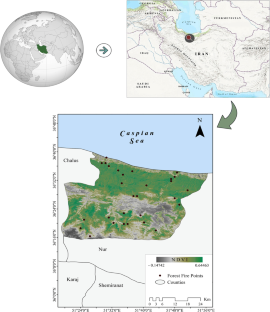
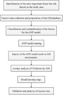
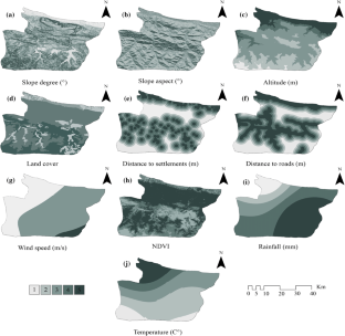
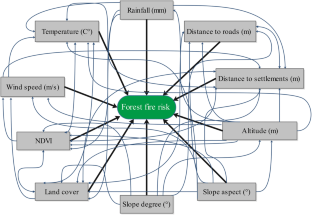
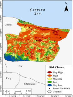
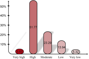
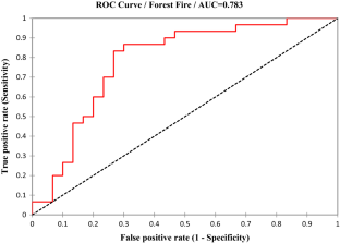
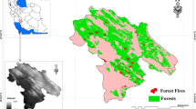
Forests are the most beautiful natural resources around the world and play a pivotal role in preserving environmental balance. An important measure taken for managing and protecting forest areas as well as for decreasing the potential damages caused by the fire is the detection of regions susceptible to forest fire through forest fire risk mapping with different models and methods. In recent years, a geographic information system (GIS)-based multi-criteria decision analyses (MCDA) have been successfully applied in the production of forest fire risk maps. In this study, GIS-based analytical network process as MCDA method was employed in order to provide the fire risk map of Noshahr Forests (North Iran) using slope, slope aspect, altitude, land cover, normalized difference vegetation index, annual rainfall, annual temperature, distance to settlements, and distance to road as input data. Furthermore, to prepare the map of the distribution of occurred fires, MODIS fire product and wide-field observations were used. Thereafter, each of these subcriteria of the utilized factors was standardized according to their significance in a forest fire and then with the extracted coefficients in the analytical network process model merged in ArcGIS software. Finally, the fire risk map was generated. Evaluation of the results obtained using receiver operating characteristic curve indicated that the designed model has good accuracy with a value of under curve area of 0.783. According to the map prepared, 57.45% of the study area (1034.41 km 2 ) is located in the high and very high-risk classes.
This is a preview of subscription content, log in via an institution to check access.
Access this article
Subscribe and save
Springer+ Basic
€32.70 /Month
- Get 10 units per month
- Download Article/Chapter or eBook
- 1 Unit = 1 Article or 1 Chapter
- Cancel anytime
Buy Now
Price includes VAT (France)
Instant access to the full article PDF.
Rent this article via DeepDyve
Producing forest fire susceptibility map via multi-criteria decision analysis and frequency ratio methods
Article 10 July 2020
Detection of high fire risk areas in Zagros Oak forests using geospatial methods with GIS techniques
Article 23 April 2022

Forest Fire Risk Modeling Using GIS and Remote Sensing in Major Landscapes of Himachal Pradesh
Chapter © 2022
References
- Abdullah, L., & Rahman, N. A. A. (2017). Analytic network process for developing relative weight of wastewater treatment technology selection. Modern Applied Science,11, 64. ArticleGoogle Scholar
- Adab, H., Kanniah, D., & Solaimani, K. (2011). GIS-based probability assessment of fire risk in grassland and forested landscapes of Golestan Province, Iran. In International conference on environmental and computer science IPCBEE (pp. 170–175).
- Adab, H., Kanniah, K. D., & Solaimani, K. (2013). Modeling forest fire risk in the northeast of Iran using remote sensing and GIS techniques. Natural Hazards,65, 1723–1743. ArticleGoogle Scholar
- Agee, J. K., & Skinner, C. N. (2005). Basic principles of forest fuel reduction treatments. Forest Ecology and Management,211, 83–96. ArticleGoogle Scholar
- Ahmadi, H., Nilashi, M., & Ibrahim, O. (2015). Organizational decision to adopt hospital information system: An empirical investigation in the case of Malaysian public hospitals. International Journal of Medical Informatics,84, 166–188. ArticleGoogle Scholar
- Aleemahmoodi Sarab, S., Feghhi, J., Danehkar, A., & Attarod, P. (2015). Effects of dereference evapotranspiration and relative humidity on forest fire occurrences in Zagros Forests, west of Iran (Case study: Khouzestan province). Forest and Range Protection Research,12, 79–86. Google Scholar
- Alexandrian, D., & Esnault, F. (1999). Public policies affecting forest fires in the Mediterranean Basin. FAO forestry paper 39-58.
- Alexandridis, A., Vakalis, D., Siettos, C. I., & Bafas, G. V. (2008). A cellular automata model for forest fire spread prediction: The case of the wildfire that swept through Spetses Island in 1990. Applied Mathematics and Computation,204, 191–201. ArticleGoogle Scholar
- Althouse, A. D. (2016). Statistical graphics in action: Making better sense of the ROC curve. International Journal of Cardiology,215, 9. ArticleGoogle Scholar
- Argañaraz, J. P., Pizarro, G. G., Zak, M., Landi, M. A., & Bellis, L. M. (2015). Human and biophysical drivers of fires in Semiarid Chaco mountains of Central Argentina. Science of the Total Environment,520, 1–12. ArticleGoogle Scholar
- Arpaci, A., Malowerschnig, B., Sass, O., & Vacik, H. (2014). Using multi variate data mining techniques for estimating fire susceptibility of Tyrolean forests. Applied Geography,53, 258–270. ArticleGoogle Scholar
- Artsybashev, E. (1983). Forest fires and their control. New Delhi: Oxonian. Google Scholar
- Bagheri, A., & Ghorbani, A. (2011). Adoption and non-adoption of sprinkler irrigation technology in Ardabil Province of Iran. African Journal of Agricultural Research,6, 1085–1089. Google Scholar
- Bathrellos, G. D., Skilodimou, H. D., Chousianitis, K., Youssef, A. M., & Pradhan, B. (2017). Suitability estimation for urban development using multi-hazard assessment map. Science of the Total Environment,575, 119–134. ArticleGoogle Scholar
- Brown, A. A., & Davis, K. P. (1973). Forest fire: Control and use. New York: McGraw-Hill. Google Scholar
- Bui, D. T., Bui, Q.-T., Nguyen, Q.-P., Pradhan, B., Nampak, H., & Trinh, P. T. (2017). A hybrid artificial intelligence approach using GIS-based neural-fuzzy inference system and particle swarm optimization for forest fire susceptibility modeling at a tropical area. Agricultural and Forest Meteorology,233, 32–44. ArticleGoogle Scholar
- Chiang, Y.-M., Chen, W.-L., & Ho, C.-H. (2016). Application of analytic network process and two-dimensional matrix evaluating decision for design strategy. Computers and Industrial Engineering,98, 237–245. ArticleGoogle Scholar
- Chuvieco, E., & Congalton, R. G. (1989). Application of remote sensing and geographic information systems to forest fire hazard mapping. Remote Sensing of Environment,29, 147–159. ArticleGoogle Scholar
- Chuvieco, E., & Salas, J. (1996). Mapping the spatial distribution of forest fire danger using GIS. International Journal of Geographical Information Science,10, 333–345. Google Scholar
- Constantin, M., Bednarik, M., Jurchescu, M. C., & Vlaicu, M. (2011). Landslide susceptibility assessment using the bivariate statistical analysis and the index of entropy in the Sibiciu Basin (Romania). Environmental Earth Sciences,63, 397–406. ArticleGoogle Scholar
- Cooper, J. A., Miller, G. J., & Humphries, S. E. (2005). A comparison of the PROCAM and Framingham point-scoring systems for estimation of individual risk of coronary heart disease in the Second Northwick Park Heart Study. Atherosclerosis,181, 93–100. ArticleGoogle Scholar
- Darand, M., Amanollahi, J., & Zandkarimi, S. (2017). Evaluation of the performance of TRMM multi-satellite precipitation analysis (TMPA) estimation over Iran. Atmospheric Research,190, 121–127. ArticleGoogle Scholar
- Dingman, S. L., Seely-Reynolds, D. M., & Reynolds, R. C. (1988). Application of kriging to estimating mean annual precipitation in a region of orographic influence. JAWRA Journal of the American Water Resources Association,24, 329–339. ArticleGoogle Scholar
- Dong, X., Li-min, D., Guo-fan, S., Lei, T., & Hui, W. (2005). Forest fire risk zone mapping from satellite images and GIS for Baihe Forestry Bureau, Jilin, China. Journal of Forestry Research,16, 169–174. ArticleGoogle Scholar
- Erten, E., Kurgun, V., & Musaoglu, N. (2004). Forest fire risk zone mapping from satellite imagery and GIS: a case study. In 20th congress of the international society for photogrammetry and remote sensing (pp. 222–230). Istanbul.
- Esfahani, M. D., Ramayah, T., & Nilashi, M. (2017). Modelling upper echelons’ behavioural drivers of green IT/IS adoption using an integrated Interpretive structural modelling-analytic network process approach. Telematics and Informatics,34, 583–603. ArticleGoogle Scholar
- Eugenio, F. C., Dos Santos, A. R., Fiedler, N. C., Ribeiro, G. A., da Silva, A. G., Dos Santos, Á. B., et al. (2016). Applying GIS to develop a model for forest fire risk: A case study in Espírito Santo, Brazil. Journal of Environmental Management,173, 65–71. ArticleGoogle Scholar
- FAO. (2015). Global forest resources assessment 2015. Rome: Food and Agriculture Organization of the United Nations. Google Scholar
- Faramarzi, H., Hosseini, S. M., & Gholamalifard, M. (2014). Fire hazard zoning in national golestan park using logistic regression and GIS. Geography and Environmental Hazards,3, 73–90. Google Scholar
- Feizizadeh, B., Omrani, K., & Aghdam, F. B. (2015). Fuzzy analytical hierarchical process and spatially explicit uncertainty analysis approach for multiple forest fire risk mapping. GI_Forum,2015, 72–80. ArticleGoogle Scholar
- Fernandes, A. M., Utkin, A. B., Lavrov, A. V., & Vilar, R. M. (2004). Development of neural network committee machines for automatic forest fire detection using lidar. Pattern Recognition,37, 2039–2047. ArticleGoogle Scholar
- Gandhi, M. (2016). Unsustainable use of natural resources. People, Planet, and Progress Beyond,2015, 105. Google Scholar
- Gao, J.-X., Chen, Y.-M., Lü, S.-H., Feng, C.-Y., Chang, X.-L., Ye, S.-X., et al. (2012). A ground spectral model for estimating biomass at the peak of the growing season in Hulunbeier grassland, Inner Mongolia, China. International Journal of Remote Sensing,33, 4029–4043. ArticleGoogle Scholar
- Garavand, S., Yaralli, N., & Sadeghi, H. (2013). Spatial pattern and mapping fire risk occurrence at natural lands of Lorestan province. Rangelands and Forests Plant Breeding and Genetic Research,21, 231–242. Google Scholar
- Garen, D. C., Johnson, G. L., & Hanson, C. L. (1994). Mean areal precipitation for daily hydrologic modeling in mountainous regions. JAWRA Journal of the American Water Resources Association,30, 481–491. ArticleGoogle Scholar
- Goldarag, Y. J., Mohammadzadeh, A., & Ardakani, A. (2016). Fire risk assessment using neural network and logistic regression. Journal of the Indian Society of Remote Sensing,44, 1–10. ArticleGoogle Scholar
- Hashemi, S. H., Karimi, A., & Tavana, M. (2015). An integrated green supplier selection approach with analytic network process and improved Grey relational analysis. International Journal of Production Economics,159, 178–191. ArticleGoogle Scholar
- Hevesi, J. A., Istok, J. D., & Flint, A. L. (1992). Precipitation estimation in mountainous terrain using multivariate geostatistics. Part I: Structural analysis. Journal of Applied Meteorology,31, 661–676. ArticleGoogle Scholar
- Hunter, R. D., & Meentemeyer, R. K. (2005). Climatologically aided mapping of daily precipitation and temperature. Journal of Applied Meteorology,44, 1501–1510. ArticleGoogle Scholar
- Hussey, L. K., & Malczewski, J. (2016). Housing quality evaluation using analytic network process: A case study in the Ashanti Region, Ghana. African Geographical Review,37, 1–20. ArticleGoogle Scholar
- Jaiswal, R. K., Mukherjee, S., Raju, K. D., & Saxena, R. (2002). Forest fire risk zone mapping from satellite imagery and GIS. International Journal of Applied Earth Observation and Geoinformation,4, 1–10. ArticleGoogle Scholar
- Jharkharia, S., & Shankar, R. (2007). Selection of logistics service provider: An analytic network process (ANP) approach. Omega,35, 274–289. ArticleGoogle Scholar
- Kant Sharma, L., Kanga, S., Singh Nathawat, M., Sinha, S., & Chandra Pandey, P. (2012). Fuzzy AHP for forest fire risk modeling. Disaster Prevention and Management: An International Journal,21, 160–171. ArticleGoogle Scholar
- Kantardzic, M. (2011). Data mining: Concepts, models, methods, and algorithms. New York: Wiley. BookGoogle Scholar
- Kavzoglu, T., Sahin, E. K., & Colkesen, I. (2014). Landslide susceptibility mapping using GIS-based multi-criteria decision analysis, support vector machines, and logistic regression. Landslides,11, 425–439. ArticleGoogle Scholar
- Keenan, R. J., Reams, G. A., Achard, F., de Freitas, J. V., Grainger, A., & Lindquist, E. (2015). Dynamics of global forest area: Results from the FAO Global Forest Resources Assessment 2015. Forest Ecology and Management,352, 9–20. ArticleGoogle Scholar
- Kirytopoulos, K., Voulgaridou, D., Platis, A., & Leopoulos, V. (2011). An effective Markov based approach for calculating the limit matrix in the analytic network process. European Journal of Operational Research,214, 85–90. ArticleGoogle Scholar
- Littell, J. S., Peterson, D. L., Riley, K. L., Liu, Y., & Luce, C. H. (2016). A review of the relationships between drought and forest fire in the United States. Global Change Biology,22, 2353–2369. ArticleGoogle Scholar
- Ma, W., Fang, J., Yang, Y., & Mohammat, A. (2010). Biomass carbon stocks and their changes in northern China’s grasslands during 1982–2006. Science China Life Sciences,53, 841–850. ArticleGoogle Scholar
- Mavsar, R., Cabán, A. G., & Varela, E. (2013). The state of development of fire management decision support systems in America and Europe. Forest Policy and Economics,29, 45–55. ArticleGoogle Scholar
- Mirdeilami, T., Shataee, S., & Kavoosi, M. R. (2015). Forest fire risk zone mapping in the Golestan national park using regression logistic method. Wood and Forest Science and Technology,22, 1–16. Google Scholar
- Moritz, M. A., Parisien, M.-A., Batllori, E., Krawchuk, M. A., Van Dorn, J., Ganz, D. J., et al. (2012). Climate change and disruptions to global fire activity. Ecosphere,3, 1–22. ArticleGoogle Scholar
- Neaupane, K. M., & Piantanakulchai, M. (2006). Analytic network process model for landslide hazard zonation. Engineering Geology,85, 281–294. ArticleGoogle Scholar
- Nilashi, M., bin Ibrahim, O., & Ithnin, N. (2014). Multi-criteria collaborative filtering with high accuracy using higher order singular value decomposition and neuro-fuzzy system. Knowledge-Based Systems,60, 82–101. ArticleGoogle Scholar
- Nonomura, A., Masuda, T., & Moriya, H. (2007). Wildfire damage evaluation by merging remote sensing with a fire area simulation model in Naoshima, Kagawa, Japan. Landscape and Ecological Engineering, 3, 109–117. ArticleGoogle Scholar
- Ocampo, L. A., & Seva, R. R. (2016). Using analytic network process for evaluating mobile text entry methods. Applied Ergonomics,52, 232–241. ArticleGoogle Scholar
- Palmisano, G. O., Loisi, R. V., Ruggiero, G., Rocchi, L., Boggia, A., Roma, R., et al. (2016). Using analytic network process and dominance-based rough set approach for sustainable requalification of traditional farm buildings in Southern Italy. Land Use Policy,59, 95–110. ArticleGoogle Scholar
- Pan, J., Wang, W., & Li, J. (2016). Building probabilistic models of fire occurrence and fire risk zoning using logistic regression in Shanxi Province, China. Natural Hazards,81, 1879–1899. ArticleGoogle Scholar
- Phillips, D. L., Dolph, J., & Marks, D. (1992). A comparison of geostatistical procedures for spatial analysis of precipitation in mountainous terrain. Agricultural and Forest Meteorology,58, 119–141. ArticleGoogle Scholar
- Pourghasemi, H., Beheshtirad, M., & Pradhan, B. (2016). A comparative assessment of prediction capabilities of modified analytical hierarchy process (M-AHP) and Mamdani fuzzy logic models using Netcad-GIS for forest fire susceptibility mapping. Geomatics, Natural Hazards and Risk,7, 861–885. ArticleGoogle Scholar
- Pourtaghi, Z. S., Pourghasemi, H. R., Aretano, R., & Semeraro, T. (2016). Investigation of general indicators influencing on forest fire and its susceptibility modeling using different data mining techniques. Ecological Indicators,64, 72–84. ArticleGoogle Scholar
- Pourtaghi, Z. S., Pourghasemi, H. R., & Rossi, M. (2015). Forest fire susceptibility mapping in the Minudasht forests, Golestan Province. Iran. Environmental Earth Sciences,73, 1515–1533. ArticleGoogle Scholar
- Pradhan, B., Dini Hairi Bin Suliman, M., & Arshad Bin Awang, M. (2007). Forest fire susceptibility and risk mapping using remote sensing and geographical information systems (GIS). Disaster Prevention and Management: An International Journal,16, 344–352. ArticleGoogle Scholar
- Rahmati, O., Haghizadeh, A., Pourghasemi, H. R., & Noormohamadi, F. (2016). Gully erosion susceptibility mapping: The role of GIS-based bivariate statistical models and their comparison. Natural Hazards,82, 1231–1258. ArticleGoogle Scholar
- Razandi, Y., Pourghasemi, H. R., Neisani, N. S., & Rahmati, O. (2015). Application of analytical hierarchy process, frequency ratio, and certainty factor models for groundwater potential mapping using GIS. Earth Science Informatics,8, 867–883. ArticleGoogle Scholar
- Renard, Q., Pélissier, R., Ramesh, B., & Kodandapani, N. (2012). Environmental susceptibility model for predicting forest fire occurrence in the Western Ghats of India. International Journal of Wildland Fire,21, 368–379. ArticleGoogle Scholar
- Roy, B. (1996). Multicriteria methodology for decision aiding, volume 12 of nonconvex optimization and its applications. Dordrecht: Kluwer. BookGoogle Scholar
- Saaty, T. L. (1980). The analytic hierarchy process. New York: McGraw-Hill. Google Scholar
- Saaty, T. L. (1990). How to make a decision: The analytic hierarchy process. European Journal of Operational Research,48, 9–26. ArticleGoogle Scholar
- Saaty, T. L. (1996). Decision making with dependence and feedback: The analytic network process. Pittsburgh: RWS Publication. Google Scholar
- Saaty, T. L. (1999). Fundamentals of the analytic network process. Japan, Kobe: The International Symposium on the Analytic Hierarchy Process. Google Scholar
- Saaty, T. L. (2004). Fundamentals of the analytic network process—Multiple networks with benefits, costs, opportunities and risks. Journal of Systems Science and Systems Engineering,13, 348–379. ArticleGoogle Scholar
- Saaty, T. L., & Vargas, L. G. (2013). Decision making with the analytic network process: Economic, political, social and technological applications with benefits, opportunities, costs and risks. Berlin: Springer. BookGoogle Scholar
- Satir, O., Berberoglu, S., & Donmez, C. (2016). Mapping regional forest fire probability using artificial neural network model in a Mediterranean forest ecosystem. Geomatics, Natural Hazards and Risk,7, 1645–1658. ArticleGoogle Scholar
- Shinneman, D. J., Palik, B. J., & Cornett, M. W. (2012). Can landscape-level ecological restoration influence fire risk? A spatially-explicit assessment of a northern temperate-southern boreal forest landscape. Forest Ecology and Management,274, 126–135. ArticleGoogle Scholar
- Soto, M. E. C. (2012). The identification and assessment of areas at risk of forest fire using fuzzy methodology. Applied Geography,35, 199–207. ArticleGoogle Scholar
- Stow, D., Petersen, A., Hope, A., Engstrom, R., & Coulter, L. (2007). Greenness trends of Arctic tundra vegetation in the 1990s: Comparison of two NDVI data sets from NOAA AVHRR systems. International Journal of Remote Sensing,28, 4807–4822. ArticleGoogle Scholar
- Tien Bui, D., Pham, B. T., Nguyen, Q. P., & Hoang, N.-D. (2016). Spatial prediction of rainfall-induced shallow landslides using hybrid integration approach of least-squares support vector machines and differential evolution optimization: A case study in Central Vietnam. International Journal of Digital Earth,9, 1077–1097. ArticleGoogle Scholar
- Ussiri, D. A., & Lal, R. (2017). Global forests management for climate change mitigation. Carbon sequestration for climate change mitigation and adaptation (pp. 395–432). Berlin: Springer. BookGoogle Scholar
- Vakalis, D., Sarimveis, H., Kiranoudis, C., Alexandridis, A., & Bafas, G. (2004). A GIS based operational system for wildland fire crisis management I. Mathematical modelling and simulation. Applied Mathematical Modelling,28, 389–410. ArticleGoogle Scholar
- Verbesselt, J., Somers, B., Lhermitte, S., Jonckheere, I., Van Aardt, J., & Coppin, P. (2007). Monitoring herbaceous fuel moisture content with SPOT VEGETATION time-series for fire risk prediction in savanna ecosystems. Remote Sensing of Environment,108, 357–368. ArticleGoogle Scholar
- Voulgaridou, D., Kirytopoulos, K., & Leopoulos, V. (2009). An analytic network process approach for sales forecasting. Operational Research,9, 35–53. ArticleGoogle Scholar
- Williams, R. N., de Souza, P. A., & Jones, E. M. (2014). Analysing coastal ocean model outputs using competitive-learning pattern recognition techniques. Environmental Modelling and Software,57, 165–176. ArticleGoogle Scholar
- Xiaoge, P., Yamin, Q., & Yamin, H. (2014). An empirical study of performance evaluation of electronic resources in Chinese academic libraries based on analytic network process. Journal of Academic Libraries,4, 009. Google Scholar
- You, W., Lin, L., Wu, L., Ji, Z., Ja, Yu., Zhu, J., et al. (2017). Geographical information system-based forest fire risk assessment integrating national forest inventory data and analysis of its spatiotemporal variability. Ecological Indicators,77, 176–184. ArticleGoogle Scholar
- Yue, J., Feng, Z., Jiang, W., & Yang, X. (2007). Risk management: A probe and study on forest fires. Frontiers of Forestry in China,2, 335. ArticleGoogle Scholar
- Yüksel, İ., & Dagdeviren, M. (2007). Using the analytic network process (ANP) in a SWOT analysis—A case study for a textile firm. Information Sciences,177, 3364–3382. ArticleGoogle Scholar
- Zare, M., Pourghasemi, H. R., Vafakhah, M., & Pradhan, B. (2013). Landslide susceptibility mapping at Vaz Watershed (Iran) using an artificial neural network model: A comparison between multilayer perceptron (MLP) and radial basic function (RBF) algorithms. Arabian Journal of Geosciences,6, 2873–2888. ArticleGoogle Scholar
- Zhang, J. (2016). Weighing and realizing the environmental, economic and social goals of tourism development using an analytic network process-goal programming approach. Journal of Cleaner Production,127, 262–273. ArticleGoogle Scholar
- Zhang, J. (2017). Evaluating regional low-carbon tourism strategies using the fuzzy Delphi-analytic network process approach. Journal of Cleaner Production,141, 409–419. ArticleGoogle Scholar
- Zhang, G., Dong, J., Xiao, X., Hu, Z., & Sheldon, S. (2012). Effectiveness of ecological restoration projects in Horqin Sandy Land, China based on SPOT-VGT NDVI data. Ecological Engineering,38, 20–29. ArticleGoogle Scholar
- Ziegler, D., Laude, D., Akila, F., & Elghozi, J.-L. (2001). Time-and frequency-domain estimation of early diabetic cardiovascular autonomic neuropathy. Clinical Autonomic Research,11, 369–376. ArticleGoogle Scholar
Author information
Authors and Affiliations
- Department of Remote Sensing and GIS, Faculty of Geography and Planning, University of Tabriz, P.O. Box 51666-16471, Tabriz, Iran Hassan Abedi Gheshlaghi
- Hassan Abedi Gheshlaghi
You can also search for this author in PubMed Google Scholar
Corresponding author
Additional information
Publisher's Note
Springer Nature remains neutral with regard to jurisdictional claims in published maps and institutional affiliations.
About this article
Cite this article
Abedi Gheshlaghi, H. Using GIS to Develop a Model for Forest Fire Risk Mapping. J Indian Soc Remote Sens 47, 1173–1185 (2019). https://doi.org/10.1007/s12524-019-00981-z
- Received : 10 May 2018
- Accepted : 08 April 2019
- Published : 13 April 2019
- Issue Date : 01 July 2019
- DOI : https://doi.org/10.1007/s12524-019-00981-z
Share this article
Anyone you share the following link with will be able to read this content:
Get shareable link
Sorry, a shareable link is not currently available for this article.
Copy to clipboard
Provided by the Springer Nature SharedIt content-sharing initiative
Keywords
- Forest fire risk mapping
- Analytical network process
- Environmental preservation
- GIS
